Worsley Urban
Toronto
How a Developer Evaluates Your Toronto Land: What Happens in the First Look at a Site
Last updated: October 23, 2026
How do developers evaluate land in Toronto? They read a site through four lenses, the land, the market, the economics and the people involved, starting with what the Official Plan and Zoning By-law 569-2013 already permit before anyone talks about value. That first look usually happens long before a drawing exists, and it decides whether a property becomes a project, a partnership, a long-term hold or nothing at all.
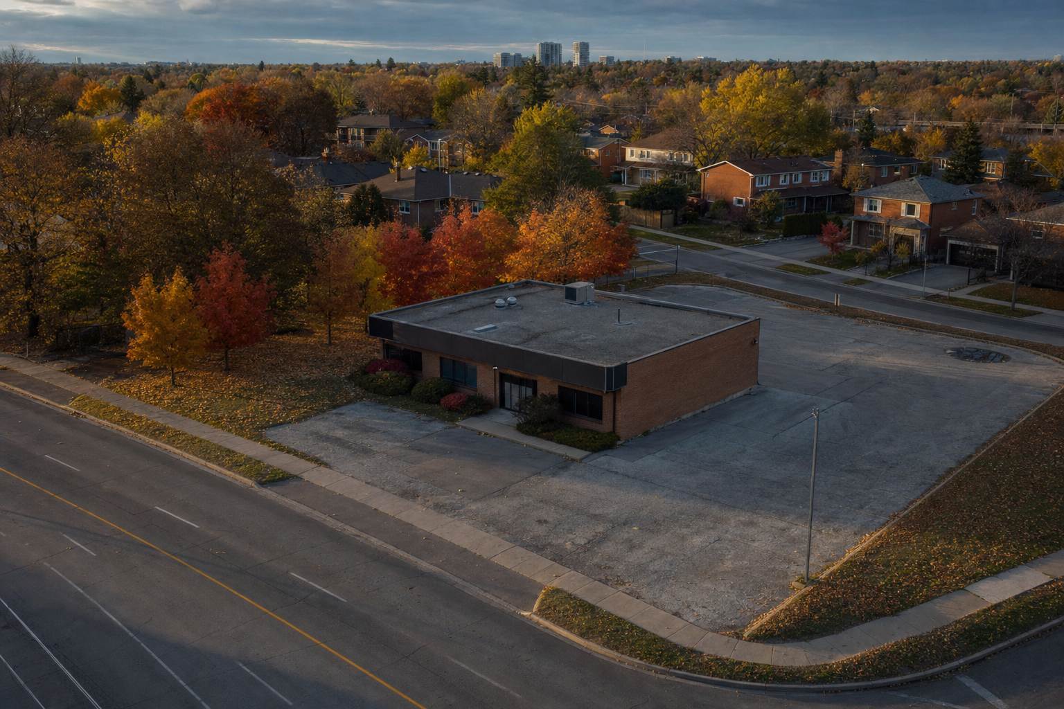
If you own a property that feels underused, such as a single-storey commercial building on a main street, a former gas station lot or a family-held parcel nobody has revisited in years, this is the process a serious developer runs before making you any proposal. Knowing the steps lets you judge whoever is looking at your land.
- A developer's first look starts with as-of-right permissions under the Official Plan and Zoning By-law 569-2013, not with a price.
- Rezoning potential is a separate question: at 2699 Keele Street in Downsview, City staff recommended the Zoning By-law amendment in June 2022 and Council approved it in July 2022.
- Site constraints (frontage, depth, servicing, heritage and neighbours) often decide the building more than the zoning does.
- Transit and access matter: Totem Condominiums at 17 Dundonald Street is an 18-storey tower whose approved building includes a secondary entrance to Wellesley station.
- The owner's goals and timeline shape the structure: sale, partnership or a developer leading entitlement on the owner's behalf.
- The seven steps a developer works through on a first look at a site, in order.
- Which public records answer each question, from the Official Plan to the Application Information Centre.
- Why a corner lot and a mid-block lot of similar size can lead to very different buildings.
- Where first assessments commonly go wrong, and what that means for an owner.
- What questions to ask any developer who wants to talk about your property.
How Do Developers Evaluate Land in Toronto: The Four Lenses
Developers evaluate land through four lenses that Worsley Urban sets out on its own site: the land, the market, the economics and the people involved. Each lens answers a different question. None of them can be skipped.
| Lens | The question it answers | Where the answer comes from |
|---|---|---|
| The land | What is permitted now, what could be earned, and what the physical site allows | Official Plan, Zoning By-law 569-2013, survey, title, heritage register, servicing records |
| The market | Who would buy, rent or lease what could be built here | The street itself, nearby approvals, transit, the surrounding neighbourhood's needs |
| The economics | Whether the project can carry its costs, risks and time | Construction costs, municipal charges, financing conditions, approval timelines |
| The people | What the owner wants, what neighbours and the City will support | Conversations with the owner, local councillor's office, past community feedback on nearby files |
The order matters. A market story built on a site that cannot be serviced, or an economic model built on density the City will never approve, wastes everyone's time. That is why land comes first.
The Process, Step by Step
A developer's first look at a site follows a predictable sequence of seven steps. Each step uses public records an owner can also read.
The Official Plan designation tells you what the City intends for the area, such as Mixed Use Areas, Neighbourhoods or Employment Areas. Zoning By-law 569-2013 then sets the uses, height, density and setbacks allowed without any application. This is the floor of what the land is worth to build on.
A Zoning By-law amendment can permit more than the current zoning, if it fits the Official Plan and the policies for the area. The developer reads recent approvals nearby in the Application Information Centre to see what the City has accepted on comparable streets. Rezoning potential is a possibility, not an entitlement, and the time and risk of earning it are part of the evaluation.
Frontage and lot depth decide whether a building can step back from the low-rise houses behind it, fit a ramp to underground parking and still leave usable floor plates. Water, sanitary and storm capacity, any heritage listing, easements on title and the condition of the soil (especially on former industrial or gas station land) all follow.
Proximity to a subway, LRT or GO station can change the planning permissions available, because the City sets specific zoning for Major Transit Station Areas. Vehicle access, loading and the road the site fronts onto also shape what can be built.
The question is not only "how much can go here" but "who wants it". Condominium residences, rental, neighbourhood retail at grade or multi-tenant industrial each answer to a different buyer or tenant, and the right use is the one the street and the surrounding community actually need.
The developer weighs what the finished project could be worth against construction, municipal charges, financing, professional fees and the carrying cost of time spent in approvals. A taller building is not automatically better: deeper excavation, concrete construction and longer approval periods can erase the benefit of extra floors.
An owner who wants a clean sale needs a different path from one who wants to keep an interest, hold income, or pass the property to the next generation. The timeline (months versus years) often determines whether the right move is a sale, a partnership, or a developer leading entitlement before anyone decides.
Tools We Use
The tools behind a first look at a development site are public planning documents and records, not proprietary software. Any owner can open them.
| Tool | What it tells a developer |
|---|---|
| The City's Official Plan | The land use designation and the policies that guide any change, including where growth is directed and where neighbourhoods are protected. |
| Zoning By-law 569-2013 | The as-of-right uses, height, density and setbacks for the lot, plus any site-specific exceptions already in force. |
| Application Information Centre | Every active and past development application nearby, with staff reports and decisions, showing what the City has supported on similar sites. |
| Transit maps (TTC and Metrolinx) | Distance to stations and planned lines, read alongside the City's Major Transit Station Areas zoning. |
| Title, survey and heritage register | Easements, restrictions, exact lot dimensions and whether the property or its neighbours are listed or designated heritage properties. |
The City's Major Transit Station Areas page, updated June 30, 2026, sets out zoning that applies around transit stations, which is a reminder that permissions vary by location. These rules change, and the permissions for a specific site must always be confirmed with the City and a planning professional.
How the Four Lenses Played Out on Five Real Sites
Worsley Urban's own projects show how different lenses dominate on different sites. The details below are drawn from public City applications.
2699 Keele Street, Downsview: value created through entitlement
The site at 2699 Keele Street was a former gas station beside Highway 401. As developer and development manager, Worsley carried it from acquisition strategy through planning and rezoning: City staff recommended the Zoning By-law amendment in June 2022, Council approved the rezoning in July 2022, and the site plan application has a Notice of Approval Conditions issued (applications 20 159444 NNY 06 OZ and 21 249733 NNY 06 SA). The approved project is a mixed-use condominium of more than 400 residences over grade-level retail. The value here came from entitlement and strategy before construction.
The Roncy, Roncesvalles Village: a constrained main-street site
The Roncy at 422 to 436 Roncesvalles Avenue replaced a former funeral home in an established low-rise neighbourhood. The rezoning was appealed to the Ontario Municipal Board in 2016 and settled. The completed building is 8 storeys with 93 residential units and retail at grade, plus townhomes on Howard Park Avenue (application 17 174229 STE 14 SA), with Worsley as developer and construction manager carrying approvals and the build under one roof.
Eight Forty, St. Clair West: reading a corridor's market
Eight Forty at 840 St. Clair Avenue West is an 8-storey mixed-use building with 116 residential dwelling units and 3 retail units (application 22 112796 STE 12 CD). It sits on a transit-served stretch and added scale and street-level commercial to a corridor that had neither. This is the market lens at work: the street lacked what the building supplied.
Kew, The Beach: scale the street could absorb
Kew is a four-storey residential infill condominium on Kippendavie Avenue south of Queen Street East, in one of the city's most protective neighbourhoods. It was approved through the Ontario Municipal Board (applications 09 174933 STE 32 OZ and 09 174949 STE 32 SA) and built at a scale the street could absorb. Here the people lens, meaning neighbours and context, set the ceiling.
Totem Condominiums, Church and Wellesley: transit as the defining fact
Totem Condominiums at 17 Dundonald Street is an 18-storey residential tower on a compact downtown infill site beside Wellesley subway station. The approved building includes a secondary entrance to Wellesley station (rezoning application 12 154762 STE 27 OZ), and residents moved in during 2018. On a small site, the relationship to transit shaped both the case for height and the public benefit.
Where It Gets Tricky
Land evaluation most often goes wrong when someone treats rezoning potential as if it were already approved. A neighbouring tower does not mean the same height is available next door; it may have depended on a larger lot, a corner location, a transit station or a settlement specific to that file. A common mistake is pricing land on a density the site cannot physically hold once setbacks, angular planes and parking ramps are drawn.
Physical surprises are the second trap. Former gas stations and industrial parcels can carry soil contamination that requires environmental assessment and remediation before any building permit. Servicing capacity in older streets may be limited. A heritage listing on the property or the one beside it can reshape the design. These are checked early because they are expensive to discover late.
Time is the third. Approvals can be appealed, as The Roncy's rezoning was to the Ontario Municipal Board in 2016, and provincial and municipal rules change during a project's life. Construction costs and financing conditions move too. A first look that assumes today's rules and costs will hold for years is incomplete. Owners should take their own legal, tax and financial advice for a specific property.
What This Means for You as the Customer
For a landowner, understanding how developers evaluate land turns a vague offer into something you can test. If you are a family that has held a main-street retail building for decades and a developer calls with interest, you can now ask what they think is permitted, what they think could be earned, and how long that would take.
Useful questions to ask anyone assessing your site:
- What does Zoning By-law 569-2013 allow on my lot today, and which exception applies, if any?
- Which nearby applications in the Application Information Centre support your view of what could be approved?
- What site constraints (frontage, depth, servicing, heritage, soil) could change the answer?
- Is your proposal based on as-of-right permissions or on a rezoning that has not been earned yet?
- Who carries the cost and risk of approvals, and what happens if they take longer than expected?
- Can I keep an interest in the project, or is this only a purchase?
The answers will tell you whether you are speaking to someone who has read the land or someone who has read a headline. Expect clear reasoning, named documents and honest uncertainty.
Our view
In our opinion, owners tend to overweight height. The tallest building a site could theoretically hold is rarely the best outcome. Kew in The Beach is four storeys and The Roncy is eight, and both reflect what their streets could absorb.
What matters more is the path: who leads the planning, who manages the approvals, who carries the project through construction, and how the owner's goals are protected along the way. A property's potential only becomes value when someone executes it.
Frequently asked questions
Do I need drawings or a survey before a developer looks at my land?
A developer's first look needs only the address and basic information such as title and any existing survey. Most of the early work uses public records like the Official Plan, Zoning By-law 569-2013 and the Application Information Centre. Detailed surveys and studies come later, if the site moves forward.
What is the difference between as-of-right and a rezoning?
As-of-right permissions are what the current zoning by-law already allows without an application. A rezoning is a Zoning By-law amendment the City must approve, as at 2699 Keele Street, where staff recommended the amendment in June 2022 and Council approved it in July 2022. Rezoning adds possibility but also time and risk.
Does being near a subway station change what I can build?
Proximity to a subway or rapid transit station can change permissions, because the City applies specific zoning in Major Transit Station Areas (its page on this was updated June 30, 2026). The rules differ by station and change over time. Confirm them for your exact site with the City and a planning professional.
Do I have to sell my land to develop it?
Selling is one of several options for a landowner. A developer can also lead entitlement and development on the owner's behalf, or structure a partnership in which the owner contributes the land and the developer brings execution. Take your own legal, tax and financial advice before choosing a structure.
Sources
- Land use designations and growth policies - City Planning: Official Plan
- As-of-right zoning permissions - City Planning: Zoning By-law 569-2013
- Development applications and decisions cited for the five projects - City Planning: Application Information Centre
- Permissions varying by location near transit (updated June 30, 2026) - City Planning: Zoning for Major Transit Station Areas
Every opportunity begins with a conversation. If you are a landowner weighing the future of a property, you bring the property; Worsley brings the path to its value, from evaluation and entitlement through partnership or acquisition to completion. The Longo family entered real estate in 1921, and Dino Longo brings more than four decades across ownership, investment, development and construction. Reach out privately at worsley.ca/#contact or dlongo@longocorp.com.
Worsley Urban
Worsley Urban (worsley.ca) is a Toronto real estate investment and development firm at 3657 Lake Shore Boulevard West, Toronto.
Start a Private Conversation About Your Site's Potential